# 14.2 Road Network

The Road Network Sub-Module maintains the information regarding the road networks of the city. The road network database maintains information on various attributes that define different aspects of a road such as a road code, surface type, and hierarchy.

14.2.1 Navigation to the Road Network

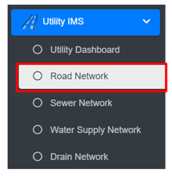
<span style="font-family: Symbol; mso-fareast-font-family: Symbol; mso-bidi-font-family: Symbol;"><span style="mso-list: Ignore;">·<span style="font: 7.0pt 'Times New Roman';"> </span></span></span>Open the sidebar and click on ‘***Utility IMS’*** to expand.

<span style="font-family: Symbol; mso-fareast-font-family: Symbol; mso-bidi-font-family: Symbol;"><span style="mso-list: Ignore;">·<span style="font: 7.0pt 'Times New Roman';"> </span></span></span>Select the **Road Network.**

![](http://152.42.244.158/knowledge-product/uploads/images/gallery/2025-02/embedded-image-ulispwg0.png)

• This redirects to the Road Network page.

**Overview:**

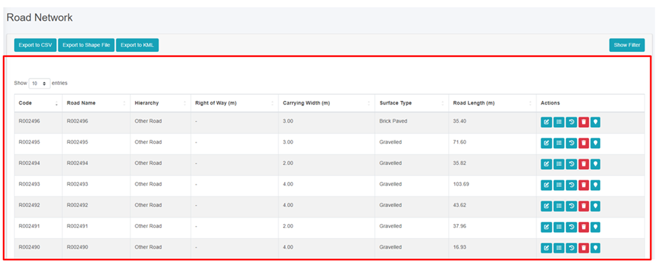
The Road Network Page lists all the attribute records stored in the module and provides different Filters, Actions and Tools that can be used according to the requirements. For more details (refer to section 5 Filters, section 6 Actions and section 8 Tools).
![](http://152.42.244.158/knowledge-product/uploads/images/gallery/2025-02/embedded-image-5o0gab33.png)

Figure 14- <span style="mso-no-proof: yes;">2</span> List of Road Network

14.2.2 Add roads

<span style="font-family: Symbol; mso-fareast-font-family: Symbol; mso-bidi-font-family: Symbol;"><span style="mso-list: Ignore;">·<span style="font: 7.0pt 'Times New Roman';"> </span></span></span>To add roads, go to the Map page.

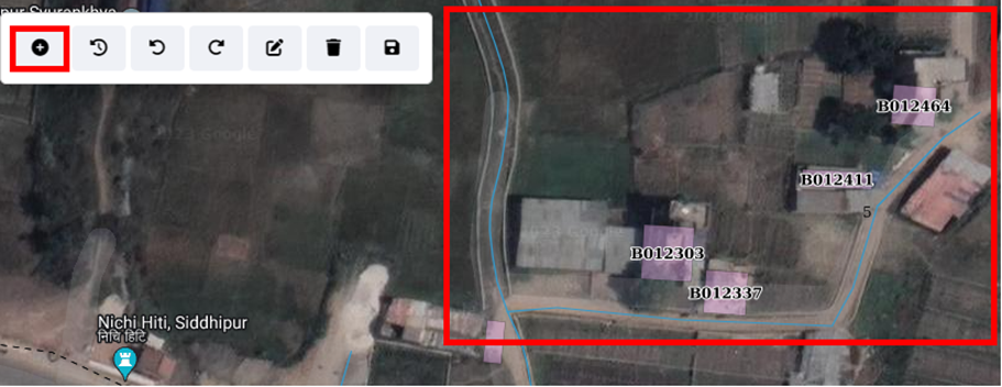
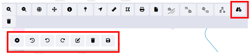
<span style="font-family: Symbol; mso-fareast-font-family: Symbol; mso-bidi-font-family: Symbol;"><span style="mso-list: Ignore;">·<span style="font: 7.0pt 'Times New Roman';"> </span></span></span>Click on the ***add road*** button, this will turn on sub-tool features to add the road line and its other related information.
![](http://152.42.244.158/knowledge-product/uploads/images/gallery/2025-02/embedded-image-dp63y5th.png)

Figure 14- <span style="mso-no-proof: yes;">3</span> Map Tools

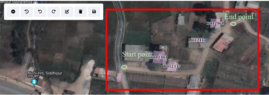
<span style="font-family: Symbol; mso-fareast-font-family: Symbol; mso-bidi-font-family: Symbol;"><span style="mso-list: Ignore;">·<span style="font: 7.0pt 'Times New Roman';"> </span></span></span><span class="normaltextrun"><span style="color: black; background: white;">To add a new road, the user need to locate the tentative location of the starting point and ending point of a new road constructed through the map feature interface.</span></span>

<span class="normaltextrun">![](http://152.42.244.158/knowledge-product/uploads/images/gallery/2025-02/embedded-image-q1se1j1x.png)</span>

Figure 14- <span style="mso-no-proof: yes;">4</span> Locating the new road section

<span style="font-family: Symbol; mso-fareast-font-family: Symbol; mso-bidi-font-family: Symbol;"><span style="mso-list: Ignore;">·<span style="font: 7.0pt 'Times New Roman';"> </span></span></span><span class="normaltextrun"><span style="color: black; background: white;">Once the new road section has been identified, the user must tentatively outline the new road on the map interface by creating a set of points.</span></span>

<span class="normaltextrun">![](http://152.42.244.158/knowledge-product/uploads/images/gallery/2025-02/embedded-image-zdb13zhr.png)</span>

Figure 14- <span style="mso-no-proof: yes;">5</span> Add new road section

<span style="font-family: Symbol; mso-fareast-font-family: Symbol; mso-bidi-font-family: Symbol;"><span style="mso-list: Ignore;">·<span style="font: 7.0pt 'Times New Roman';"> </span></span></span>If the user is not satisfied with the drawn road line on the map, they can undo, redo, or remove it by clicking the corresponding button.

![](http://152.42.244.158/knowledge-product/uploads/images/gallery/2025-02/embedded-image-tpzzmjdt.png)

Figure 14- <span style="mso-no-proof: yes;">6</span> Undo, Redo and Remove

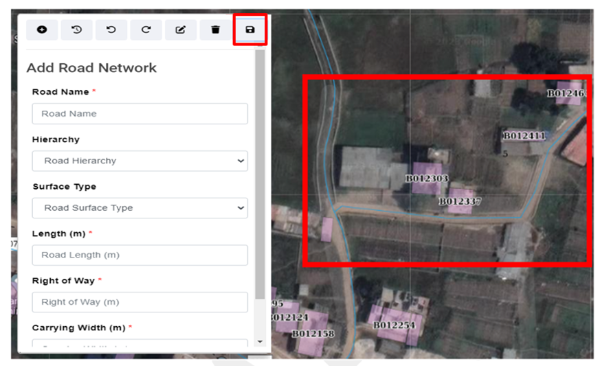
<span style="font-family: Symbol; mso-fareast-font-family: Symbol; mso-bidi-font-family: Symbol;"><span style="mso-list: Ignore;">·<span style="font: 7.0pt 'Times New Roman';"> </span></span></span><span class="normaltextrun"><span style="color: black; background: white;">Upon generating an acceptable outline of the new road, the user must enter the information of the new road and save the information.</span></span>

<span class="normaltextrun">![](http://152.42.244.158/knowledge-product/uploads/images/gallery/2025-02/embedded-image-fdsnkr5w.png)</span>

Figure 14- <span style="mso-no-proof: yes;">7</span> Attribute Information of new road section

**Add Road Form**

<span style="font-family: Symbol; mso-fareast-font-family: Symbol; mso-bidi-font-family: Symbol;"><span style="mso-list: Ignore;">·<span style="font: 7.0pt 'Times New Roman';"> </span></span></span>Road Name: The name of the road.

<span style="font-family: Symbol; mso-fareast-font-family: Symbol; mso-bidi-font-family: Symbol;"><span style="mso-list: Ignore;">·<span style="font: 7.0pt 'Times New Roman';"> </span></span></span>Road Hierarchy: The hierarchy of the road from the dropdown.

<span style="font-family: Symbol; mso-fareast-font-family: Symbol; mso-bidi-font-family: Symbol;"><span style="mso-list: Ignore;">·<span style="font: 7.0pt 'Times New Roman';"> </span></span></span>Road Surface Type: The surface type of the road from the dropdown.

<span style="font-family: Symbol; mso-fareast-font-family: Symbol; mso-bidi-font-family: Symbol;"><span style="mso-list: Ignore;">·<span style="font: 7.0pt 'Times New Roman';"> </span></span></span>Road Length (m): The length of the added road.

<span style="font-family: Symbol; mso-fareast-font-family: Symbol; mso-bidi-font-family: Symbol;"><span style="mso-list: Ignore;">·<span style="font: 7.0pt 'Times New Roman';"> </span></span></span>Right of Way: <span style="mso-spacerun: yes;"> </span>The width of the road designated for vehicles and pedestrians, Right of Way value must be greater than or equal to the carrying width of the road.

<span class="normaltextrun"><span style="font-family: Symbol; mso-fareast-font-family: Symbol; mso-bidi-font-family: Symbol;"><span style="mso-list: Ignore;">·<span style="font: 7.0pt 'Times New Roman';"> </span></span></span></span>Carrying Width of the Road (m): The area designated for vehicle movement, excluding non-traffic zones.

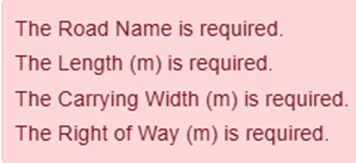
<span class="normaltextrun"><span style="font-family: Symbol; mso-fareast-font-family: Symbol; mso-bidi-font-family: Symbol;"><span style="mso-list: Ignore;">·<span style="font: 7.0pt 'Times New Roman';"> </span></span></span></span><span class="normaltextrun"><span style="color: black; background: white;">To save a road line drawing, users must complete required fields marked with red asterisks. Submitting without completing these fields will result in an error message:</span></span>

<span class="normaltextrun">![](http://152.42.244.158/knowledge-product/uploads/images/gallery/2025-02/embedded-image-gl3g0wrb.png).</span>

<span class="normaltextrun">14.2.3 Edit Road</span>

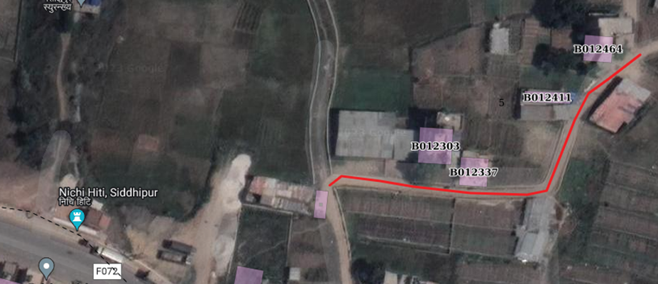
<span style="font-family: Symbol; mso-fareast-font-family: Symbol; mso-bidi-font-family: Symbol; color: black; mso-themecolor: text1;"><span style="mso-list: Ignore;">·<span style="font: 7.0pt 'Times New Roman';"> </span></span></span><span class="normaltextrun"><span style="color: black; background: white;">In addition to updating new road lines, the tool offers the capability to extend or modify existing road lines directly through the map interface, providing users with a means to update road information as urban infrastructure evolves.</span></span>

<span class="normaltextrun">![](http://152.42.244.158/knowledge-product/uploads/images/gallery/2025-02/embedded-image-wacocy6u.png)</span>

Figure 14- <span style="mso-no-proof: yes;">8</span> Spatial information of new road section

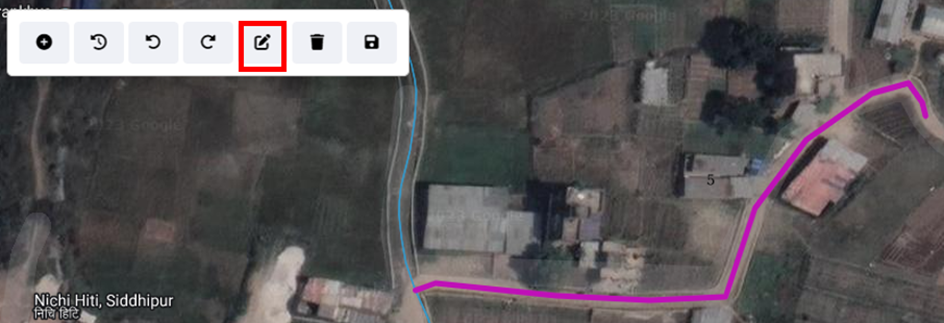
<span class="normaltextrun"><span style="font-family: Symbol; mso-fareast-font-family: Symbol; mso-bidi-font-family: Symbol; color: black; mso-themecolor: text1; mso-bidi-font-style: italic;"><span style="mso-list: Ignore;">·<span style="font: 7.0pt 'Times New Roman';"> </span></span></span></span><span class="normaltextrun"><span style="color: black; background: white;">To extend an existing road or change its route, users can activate the edit feature. </span></span>

<span class="normaltextrun"><span style="font-family: Symbol; mso-fareast-font-family: Symbol; mso-bidi-font-family: Symbol; color: black; mso-themecolor: text1;"><span style="mso-list: Ignore;">·<span style="font: 7.0pt 'Times New Roman';"> </span></span></span></span><span class="normaltextrun"><span style="color: black; background: white;">First, select the desired road from the map interface, which is highlighted for easy identification (refer to </span></span>Figure 14- 8)<span class="normaltextrun"><span style="color: black;">.<span style="background: white;"> </span></span></span>

<span class="normaltextrun"><span style="font-family: Symbol; mso-fareast-font-family: Symbol; mso-bidi-font-family: Symbol; color: black; mso-themecolor: text1;"><span style="mso-list: Ignore;">·<span style="font: 7.0pt 'Times New Roman';"> </span></span></span></span><span class="normaltextrun"><span style="color: black; background: white;">Next, select a point along the road line that requires modification and dragging or moving the point to adjust its position as needed. </span></span>

<span class="eop"><span style="font-family: Symbol; mso-fareast-font-family: Symbol; mso-bidi-font-family: Symbol; color: black; mso-themecolor: text1;"><span style="mso-list: Ignore;">·<span style="font: 7.0pt 'Times New Roman';"> </span></span></span></span><span class="normaltextrun"><span style="color: black; background: white;">This process enables precise edits to the road line's shape when necessary. Moreover, users can easily extend the road line by selecting the endpoint of the road and dragging it to reflect the actual road extension. This functionality allows users to accurately update and extend road networks directly through the map interface.</span></span><span class="eop"><span style="color: black; background: white;"> </span></span>

<span class="eop">![](http://152.42.244.158/knowledge-product/uploads/images/gallery/2025-02/embedded-image-vxq6wjcf.png)</span>

Figure 14- <span style="mso-no-proof: yes;">9</span> Updated Road line

**Note:**

<span style="font-family: Symbol; mso-fareast-font-family: Symbol; mso-bidi-font-family: Symbol;"><span style="mso-list: Ignore;">·<span style="font: 7.0pt 'Times New Roman';"> </span></span></span>Deletion of road data is not permitted when it is associated with building data.

<span style="font-family: Symbol; mso-fareast-font-family: Symbol; mso-bidi-font-family: Symbol;"><span style="mso-list: Ignore;">·<span style="font: 7.0pt 'Times New Roman';"> </span></span></span>Deletion of road data is not permitted when it is associated with sewer data.

<span style="font-family: Symbol; mso-fareast-font-family: Symbol; mso-bidi-font-family: Symbol;"><span style="mso-list: Ignore;">·<span style="font: 7.0pt 'Times New Roman';"> </span></span></span>Deletion of road data is not permitted when it is associated with water supply data.

<span style="font-family: Symbol; mso-fareast-font-family: Symbol; mso-bidi-font-family: Symbol;"><span style="mso-list: Ignore;">·<span style="font: 7.0pt 'Times New Roman';"> </span></span></span>Deletion of road data is not permitted when it is associated with drain data.