Building Information Collection Mobile App User Manual
- BIC
- Introduction
- Login
- Dashboard
- Collecting Building Information
- Uploading Building Information
- Miscellaneous(Permissions)
BIC
|
Building Information Collection Mobile App User Manual |
|
© 2022-2025 by ISPL & GWSC-AIT is licensed under CC BY-NC-SA 4.0 Version 1.0.0 |
Introduction
Purpose
The purpose of the document is to guide municipal staff memebrs on the functionalities of Building Information Collection Mobile App of Base IMIS that is used for collecting building footprints of newly constructed or identified missing buildings. It details step by step procedure of all the functionalities within the app. The app serves as a mobile tool to aid the Municipality to digitize, maintain and update the building database within the municipality. The collected building data from this app goes through further verification process via Web application of Base IMIS which also includes addition of necessary attribute data to create and maintain a complete dataset of buildings. While approving the new building through the web-GIS interface, the centroid of the collected building footprint serves as the geographical location of the containment. This app works hand in hand with the web application, functioning as a complementary tool to enhance its capabilities.
Targeted User(s)
The targeted users of this manual are the municipal staff members.
App Installation
An APK file will be made available in common access location or shared via link that can be downloaded and installed on your device.
Installation Procedure
- Download the APK file in your device and go to ‘Downloads’ folder using the ‘File Manager’.
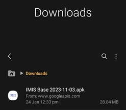


Figure 1-1 APK file
-
Locate the corresponding .apk file and tap on it. The installation process will begin.
-
Tap on ‘INSTALL button. An “Installing…” progress bar will be displayed.
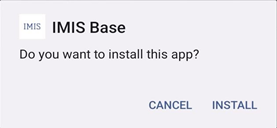

Figure 1-2 installation process
-
Tap on ‘OPEN button after installation process is completed.
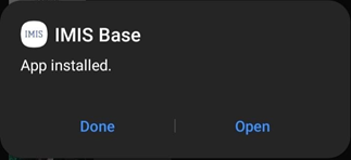

Figure 1-3
Overview:
-
The installed app can also be accessed from App drawer or Launcher.


Login
Opening the app
- On opening the app for the first time, the user is asked for their login credentials.
- Enter email address and password provided in textbox.
- Click on ‘Log in' button.
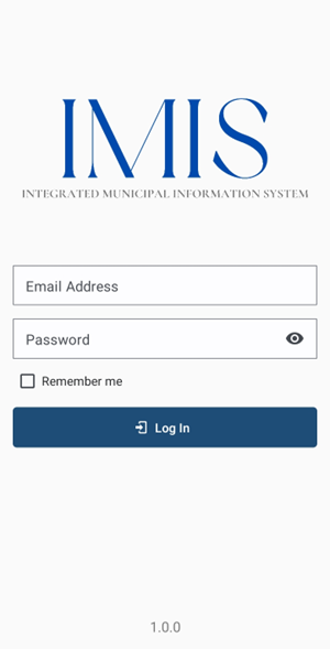
Figure 2-1 Login
Overview:
- This login credential is created and provided by the Municipality Admin to the Engineering and Building Permit Department.
- The app retains the login information until the user's session becomes inactive or expires.
- It is to be noted that GPS needs to be turned on while using the mobile application. When the user is using the app for the first time, the user must provide location permission to the app.
- Once successful login, the user is redirected to the Dashboard screen.
Dashboard
Navigate to Dashboard
- After successful login, a dashboard page is displayed.
- The user can select 'Building Map' option to collect new/missing building footprints.
- The user can select 'Buildings Data' to review, and upload the collected building footprint on IMIS.
- Click on the three dots at the top right corner to log out.
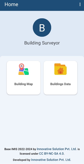
Figure 3-1 Dashboard
Overview:
- Once the user is logged in, it redirects to the dashboard page where the user has two choices: the user can either collect building data or upload building data.
- The app provides offline data collection features as well, where the collected data is stored locally on user’s device which can be uploaded to the server once online. However, to load the map and other layer features, internet connection is required. Thus, it is recommended to pre-load all map features for the area if internet connection is not available in the field.
- Once the data is uploaded successfully, it won’t be visible on the user's device.
Collecting Building Information
Building Map
Navigate to building map
-
Select the ‘Building Map’ option on the dashboard.
-
Once clicked, map interface is displayed.
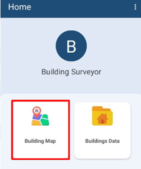
Overview:
- The Building Map option displays the map interface where the user can collect the building footprint by placing markers on the map.
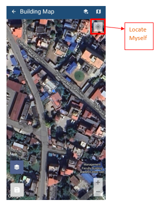
Figure 4-2 Map Interface
-
When a building's outline is already identifiable on satellite data, which is often the case for pre-existing buildings, users have the option to trace the building's corners without needing to visit the site physically. However, it is generally advised to conduct a site visit for data collection purposes.
-
When the Building Data option is selected, the user's location is automatically displayed on the map, and they can also use the "Locate Myself" button to pin-point their exact location.
-
The users may need to manually adjust the map by dragging it to align with the specific location they wish to collect building data from.
-
When there is no building footprint on the satellite data (usually a case when the building has been constructed recently), the user must physically visit the site and trace corner points of buildings.
-
In this case, the user needs to go to each corner of the building and start collecting corners of the building by tapping on the map.
Tools:
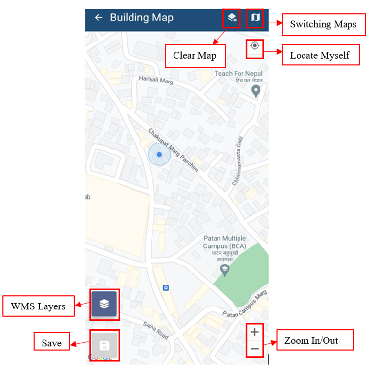

Figure 4-3 Building Map
-
Clear Map: Click to remove added marker.
-
Switching Maps: Click to toggle among various Google base maps e.g.,
Street and Satellite.
-
Locate Myself: Click to locate current position of user.
-
Zoom In/Out: Click to zoom in and out of the map.
-
WMS Layers: Click to get WMS Layers of the map. The WMS Layers is a dynamic tool that draws an overlay on the Map. It can display the different layers of data such as Building Data, Road Data and Ward data. This functionality enables the user to view the digitized data that is stored in the database. Upon clicking on the WMS Layers button, the user is prompted with a pop up to select the layers required. Upon selection, the related data layers are highlighted on the map.
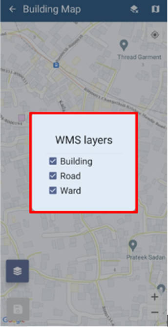
Figure 4-4 WMS Layer Toggle
- Save: Click the save icon to store the added markers.
Building data collection
- Once the map is visible, click the Locate Myself button to find the user's exact location. If the user's location point (blue marker) is not accurate on the map, then ensure one of the points is accurately placed by referencing yourself with the nearby roads and buildings displayed by the google maps and WMS layer. Then click at different positions on maps to create an approximate outline of the building using distance information shown between markers. If the user's location is accurately displayed on the map, then in that case, the user can walk to the edges of the plinth of the building and follow the blue marker that indicates the current location and place the markers accordingly.
- The user can also turn the WMS layer on to view the pre-existing buildings.
- If the user wants to delete one of the already placed markers, click on the marker to delete it.

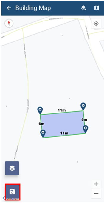
Figure 4-5 Save Button on Map
-
The distance between the markers is shown on top of the markers. The distance can be visualized by following the sequence in which the points are marked. The distance between the first and second marker is shown on top of the second marker (12m). The distance between the second and third maker is shown on top of the third marker (11m), the distance between the third and fourth marker is shown on top of the fourth marker (12m) and the distance between the fourth marker and the first marker is shown on top of the first marker (10m).
-
Once the user is satisfied with the generated outline, click Save button to accept collected building information. Click Next button to proceed.
-
The user is prompted with a dialogue box requesting for Building Identification Number (temporary) and Tax Code of the building. Fill in the data and click ‘SAVE’ button. Then after, markers in the map are cleared.
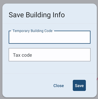

Figure 4-6 Building data collection with site visit
Overview:
-
Physically visiting the site is recommended. Go around the building to get a rough idea about orientation and length of the building. Stay at a corner of the building where it has a clear and unobstructed view of a large portion of the sky. Nearby buildings and trees can prevent GPS signals from the satellites reaching the receiver. GPS receivers on phone need some time to first acquire signals from satellites, therefore allow couple of minutes to acquire signals from satellites.
-
Crossed Polygons are not accepted such as X-shaped polygons and polygons should not overlap with existing polygons or be on the top of the road layers. Additionally, ensure that opposite sides of the buildings are parallel to each other as far as possible.

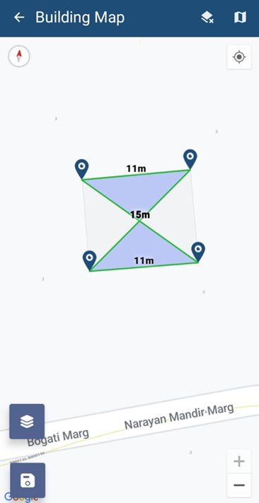
Figure: Photo displaying the crossed polygon marker
Uploading Building Information
Navigate to Building Data
- Click the Building Data button, all the building data collected are displayed in a list.
- Once clicked, displays the Buildings Data list page.

Figure 5-1 Building Data
Overview:
- Building data collected by the user are stored on the local device memory. Once the user has internet access, the user can transfer the data to IMIS.
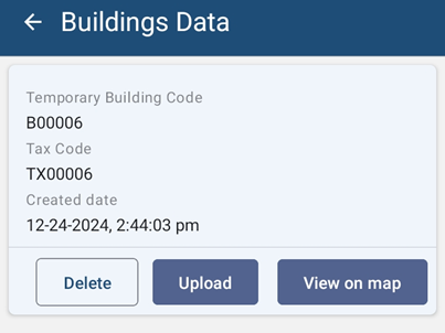
Figure 5-2 Building Data List
- Notice that the Building Identification Number (temporary) and Tax Code of the building are appended on the file name of the building data.
Tools:
Figure 5-3 Building Data Tools
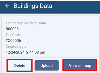
- Delete: The user can also delete the recorded data by clicking on the **'**DELETE' button. A message box will appear, to confirm the delete.
- View on Map: The user can also view the outline of the building on the map. The building footprint is displayed on the map.
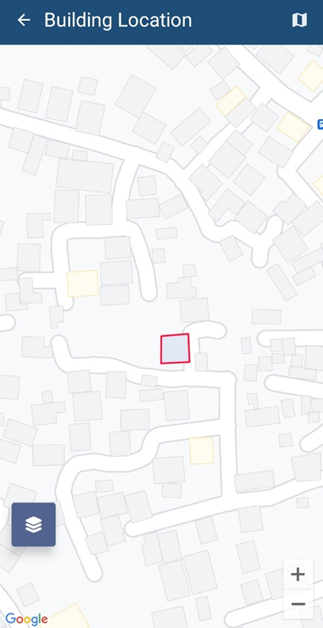
Figure 5-4 View Building on Map
Uploading Building Data
- For uploading building data to IMIS, click ‘UPLOAD’ button.
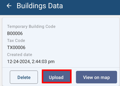

Figure 5-5 Building Data Upload
-
Once the data has been uploaded to IMIS, a message box will appear. Press OK to exit.
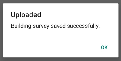

Figure 5-6 Upload Confirmation Box
Overview:
-
Once the data has been uploaded, stored data on the local device memory will be removed.
Note:
· If the user tends to upload the Building data in which it has the intersected polygon, then the system will notify with a message as:
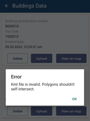
Figure: Validation Message of intersected polygon
The user has to delete the intersect polygon data and again collect a new data of the Building polygon by placing each marker on the edge of the building’s plinth and upload the data.
Miscellaneous(Permissions)
Miscellaneous
Overview:
-
When the user is using the APP for the first time, the user must provide location permission and Photo media access to the app.
-
Allow IMIS Base to access this device’s location requested by the App by clicking ‘WHILE USING THE APP’.
-
Allow IMIS Bases to access photos and media on your device, the user should click ‘ALLOW’ to grant access to the photos and media.
-
The user is also prompted to always turn on location services while using the mobile application.
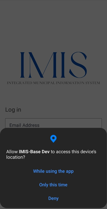
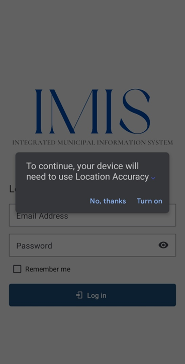
Figure 6-1 Location access
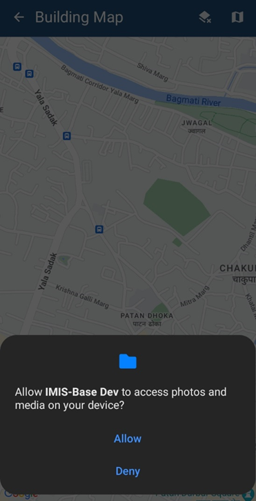
Figure 6-2 Photo and media access