Building Intial Understanding
- The Necessity and Impact of GIS based Citywide Inclusive Sanitation (G-CWIS) Training
- Scope of ToT Document and Participant’s Prerequisite
- Guidelines for Utilizing Training Module
- Suggested Training Calendar
- Data Checklist and Potential Source
The Necessity and Impact of GIS based Citywide Inclusive Sanitation (G-CWIS) Training
Citywide Inclusive Sanitation (CWIS) is a public service approach that offers significant benefits in planning, designing, and implementing various ground-level sanitation interventions. CWIS involves demonstrating improved core system functions at different administrative levels to achieve and enhance the outcomes outlined under SDG 6 - Safe, equitable, and sustainable sanitation for everyone in an urban area, with special attention to the needs of the poor and marginalized groups. The introduction of Geographic Information System (GIS) applications has provided the CWIS approach with an enriched quantitative layer to its framework, facilitating a more detailed understanding of potential interventions, even at the building footprint level as part of diverse assessment processes. The GIS based CWIS (G-CWIS) framework not only aids in comprehending the challenges and situations at hand but also helps to understand the volume and nature of required interventions across the value chain. This insight can then be translated into both investment estimates and robust regulatory provisions. This training has applications across all scales of city sanitation project planning and design, including components such as greywater and sewerage systems. Adoption of such innovation has proven to generate evidence-based planning and assists in optimizing the infrastructure needs for system transformations.
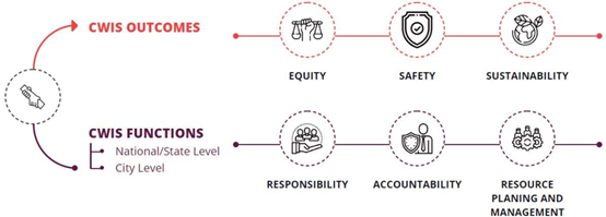
Figure 1 CWIS Service Framework
Such innovative frameworks are expected to significantly accelerate the SDG 6.2 mandate by identifying the true beneficiaries and delivering contextual sanitation solutions to safeguard against sanitation-linked public health and related issues. The G-CWIS framework has been proven and effective in answering questions like who needs to be served, where such services are required, and how they should be served. The current version of the framework, constantly improving based on project experience, has been applied in approximately 25 cities across South Asian regions, supported by BMGF and through the platform of GWSC, Thailand.
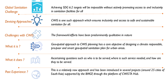
Figure 2 Need of GIS based CWIS planning applications
Scope of ToT Document and Participant’s Prerequisite
This Training of Trainers (ToT) is designed for GIS practitioners who wish to learn various technical applications of spatial planning as part of CWIS planning. A prior understanding of GIS software is a prerequisite for both trainers and trainees involved in any of the training applications. Trainees participating in this GIS-based training should have foundational knowledge of GIS concepts and familiarity with open software like QGIS. Proficiency in spatial data management, including handling formats like Shapefiles is essential. Basic cartographic principles, comprehension of spatial data collection methods, and understanding of GIS application in their specific field, particularly in developmentrelated projects, are also required. In case participants lack general GIS knowledge, a separate training focusing on GIS topics must be provided before this training.
Although the training methods suggested are flexible in nature, trainers are encouraged to explore their own methods and demonstration techniques during the training sessions. In all circumstances, a significant focus should be placed on live workshops, making it a mandatory provision. Close supervision from trainers to the participants will be required as part of these live sessions.
The participants may span a range of disciplines, including groups from private sectors involved in WASH-related projects. Furthermore, staff working in urban local bodies, development authorities, and regional offices, which are involved in providing operational support for WASH to local bodies, may also be included. This encompasses both urban and rural areas.
Guidelines for Utilizing Training Module
For optimal understanding and application of this training module, it is crucial that the outlined steps are diligently followed.
The training can be delivered both in-person and via an online platform. As a prerequisite, participants should have pre-installed QGIS software and ensure their laptop or desktop is correctly configured prior to the training sessions.
All registered participants should receive the training materials, including previous training videos, before the program commences. This allows them to familiarize themselves with the overall program and gain a detailed understanding at their own pace.
Any required databases including GIS layers of training session should also be shared with participants beforehand. These will be utilized during the training sessions, and prior understanding of data layers would be an added advantage.
For each session, at least 50% of the time should be dedicated to live workshops and practice sessions, ensuring full participant involvement. The trainer may also incorporate regular group exercises with opportunities for presentations by each group member.
The introductory session of the training program might also include a brief overview of sanitation components including introduction of FSM, CWIS, greywater management, sewer system etc. in context of Global south. which will be beneficial for later stages during workshops and live practical sessions.
Suggested Training Calendar
| Training Moule | Name | Practical Session / Live Workshop | No of hours | Suggested Days |
|---|---|---|---|---|
| I | Building initial understanding | Limited | 3 hours | 1 days |
| II | Open GIS data Extractions Process Framework | High | 12 hours | 4 days |
| III | Geospatial Assessments for CWIS Planning | High | 15 hours | 5 days |
| Total Timeline | 10 days |
Data Checklist and Potential Source
| Output Maps | Data Layer |
|---|---|
| 1. Base map | Administrative boundary |
| Water bodies | |
| Road/Rail network | |
| Land-use | |
| Building footprints | |
| Building uses | |
| Ward-wise population | |
| 2. Waterlogged Risk mapping | Elevation profile |
| Natural drainage density | |
| Storm water drainage network | |
| 3. Flood risk mapping | Highest flood level (HFL) of nearby river |
| Elevation profile | |
| 4. Water proximity settlements mapping | Buffer of water bodies |
| 5. Hard to reach settlement mapping | Applying buffers on different road width |
| In-accessible settlements | |
| Building footprints | |
| 6. LIC Settlements | Building structure types (Katcha and Pucca) |
| 7. Public Toilet – upgradation and new units | Location of all existing toilets |
| 8. FSTP Proximity Assessment Mapping | Building footprints |
| Road width and network | |
| Location of FSTP | |
| 9. Greywater management | Watershed maps |