3.9 Assessment of Pan City Level Settlements Proximity to Existing and Proposed FSTP
3.9.1 Data Requirements
1. Location of existing and proposed FSTPs
2. Network dataset using the road network layer
3.9.2 Stepwise Process Flow Details
- Step 1: Load the Network Dataset
Load the road network shapefile in QGIS, which you created earlier as a network dataset.
- Step 2: Add FSTP Locations
Add the locations of the existing and proposed FSTPs as input data for the network analysis.
- Step 3: Create Network Buffers
To create network buffers representing travel times of 15 minutes, 30 minutes, and greater than 30 minutes for truck travel from each FSTP, you can use the "QNEAT3 > Service Area (from Layer)" tool. Select the FSTP locations as the input points. Configure the travel time intervals (15 minutes, 30 minutes, and
greater than 30 minutes). Run the tool to create the network buffers centered on the FSTP locations.
- Step 4: Overlay Buffers on Settlement Data
Overlay the network buffers onto the settlement dataset. This can usually be accomplished by using an 'Overlay' or 'Intersect' function within your GIS software.
- Step 5: Overlay Buffers on Settlement Data
Overlay the network buffers onto the settlement dataset by using the "Vector > Geoprocessing Tools > Intersect" tool in QGIS.
Select the settlement dataset as the input layer and the network buffers as the overlay layer. Run the tool to create a new layer containing the intersected
features.
- Step 6: Identify Buildings within Buffers
Identify and categorize the buildings within each buffer zone using the "Vector > Research Tools > Select by Location" tool in QGIS.
Select the buildings layer as the target layer.
Choose the buffer zones (15-minute travel time, 30-minute travel time, and greater than 30-minute travel time) as the source layer.
Select the "Intersect" spatial selection method to find buildings within each buffer zone. Create a new layer with the selected buildings for each buffer category.
- Step 7: Calculate Percentages
Calculate the percentage of buildings accessible within each of the buffer categories.
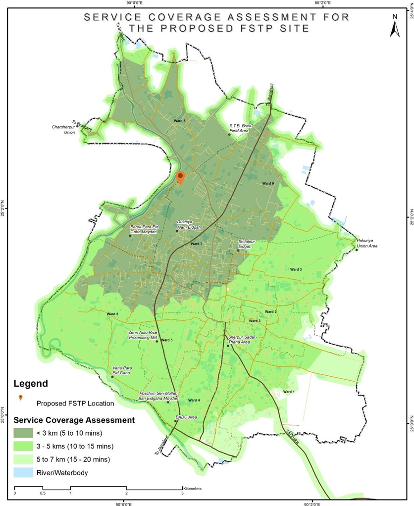
Figure 15 Illustrations of assessment of settlements proximity of proposed and existing FSTP, Sherpur (Bangladesh)
Source – CWIS spatial analysis, Innpact Solutions and GWSC
3.9.3 Output Application
This type of analysis aids in assessing the locational suitability of both existing and proposed Faecal Sludge Treatment Plant (FSTP) sites. Based on the results, areas outside of smooth travel distances might consider the possibility of implementing transfer stations or additional treatment facilities, contingent on the volume of sludge generated from their respective settlement areas. This spatial understanding provides a comprehensive approach for faecal sludge management planning and implementation across the city.
No Comments