9.2 Buildings
The Buildings sub-module maintains the detailed information about each building maintained by the Buildings sub-module, including: Physical attributes (structure type, number of floors, and year of construction); Location details (address and geographical coordinates with building footprints; Usage and ownership (Building usage, ownership status, and associated tax codes); Utilities and services (sources of water, solid waste management services, access to sanitation, access to roads, etc.); Demographics and classifications (basic demographic data and classifications for low-income community areas). Buildings are central to IMIS, functioning as the foundational entities that interconnect all other components essential for efficient municipal service delivery.
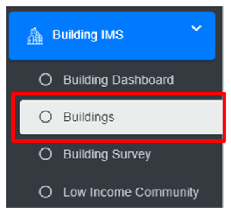
· Open the sidebar and click on the Building IMS to expand.
· Select Buildings.
Overview:
The Buildings Page lists all the attribute records stored in the module and provides different Tools, Actions and Tools that can be used according to the requirements. For more details (refer to section 5 Filters, section 6 Actions and section 8 Tools).
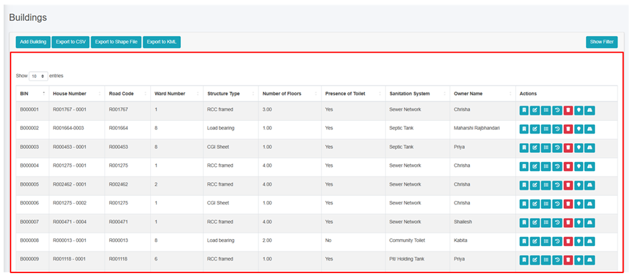
Figure 9- 2 List Buildings page
9.2.2 Add Building
· Click on the ‘Add Building’ button.

· User will be redirected to the following page:
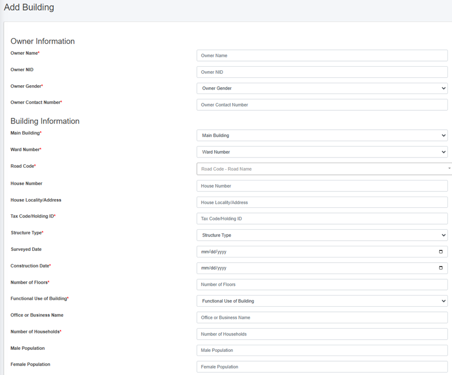
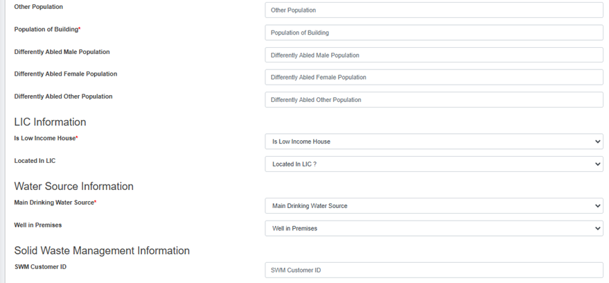
Figure 9- 3 Add Building Page
· After filling out the form, click Save and make sure a pop-up message is displayed, refer to section 7.1 Save for more details.
- If a mandatory form field is left out or any form failed validation during the form submission a validation message box will be prompted, refer to section 7.2 Validation Message Box for more details.
Overview:
The building add form is designed to collect and manage information about various attributes. It incorporates various skip logic that activates based on the information entered by the user. The details of the form fields are explained below:
Owner information
1. Owner Name - Full name of the building owner.
2. Owner NID – National Identity Card Number of the building owner.
3. Owner Gender - Gender of the building owner.
4. Owner Contact Number - Contact number of the building owner, it takes numeric values only.
Building Information
1. Main Building - Defines if the building is the main or auxiliary building. Select ‘Yes’ if it is a main building, and no if it is an auxiliary building. If ‘No’ is selected the Main Building House Number field is prompted.
· Main Building House Number - Unique identifier for the associated main building if building is auxiliary.
2. Ward Number - Identifier for the local administrative unit.
3. Road Code - Identifier for the road that the building is connected to. The dropdown menu for selecting the Road Code only displays the codes that are maintained in the Road Network sub-module of the Utility IMIS module.
4. House Number – Unique address code of the building.
5. House Locality / Address – Address of the building.
6. Tax Code / Holding ID - Identifier for the building’s tax record.
7. Structure Type - Type of the building structure.
8. Surveyed Date - Specific date on which the data collection was completed.
9. Construction Date - The date on which the building was constructed.
10. Number of Floors - Number of floors of the building, it allows only numeric values.
11. Functional Use of Building - The functional use of the building. When the subsequent Functional Use of Building is chosen, the Use Category of Buildings field is prompted which is also mandatory field to fill-up. The user can choose the use category with the following options:
|
Functional Use of Building |
Use Category of Buildings |
|
Residential |
Residential, Housing, Apartment, Orphanage, Old-aged Home, Hostel |
|
Mixed (Residential, Commercial, Office uses) |
Mixed |
|
Educational |
School, College, University, Training Center |
|
Health Institution |
Hospital, Clinic/ Health Post |
|
Commercial |
Shop, Restaurant, Hotel/ Resort, Offices (Private), Shopping mall/ Super Market, Party Palace/ Banquets, Business Complex |
|
Industrial |
Industry, Factory, Warehouse, Workshop, Printing Press |
|
Agriculture and Livestock |
Agriculture Farm, Livestocks |
|
Public Institution |
City hall, Museum, Public Library and archive, Public transportation terminal, Parking, Post office, Community Toilet, Public Toilet |
|
Government Institution
|
Municipal Office, Ward Office, Government Office, Police Office. Fire Station, Army barrack, Jail |
|
Recreational Institution |
Club, Stadium, Cinema/theatre, Sports complex, Fitness center, Recreational center |
|
Social Institution |
NGO, INGO, Political Party, Guthi house, Media, Social Group/ Samiti Bhawan |
|
Cultural and Religious |
Temple, Church, Mosque, Stupa, Hermitage (kuti), Mourning house, Bihar/Gumba, Bhajan Mandal, Cultural Centers |
|
Financial Institution |
Bank, Cooperative/ Finance |
|
Vacant/Under Construction |
Vacant building, Building under construction |
· If the user selects the options from the “Use Category of Building” that is either “Public Toilet” or “Community Toilet”, then the following fields are hidden from the add form:
§ Office or Business Name
§ Number of Households
§ Population of Building
§ Male Population
§ Female Population
§ Other Population
§ Differently Abled Male Population
§ Differently Abled Female Population
§ Differently Abled Other Population
1. Office or Business Name - Name of the business or office in the building, only prompted if the selected Functional Use is not “Residential”.
2. Number of Households - The total number of households served by the building.
3. Population of Building - Total number of individuals present within the building. This field is automatically calculated by summing the male, female and other population counts, but user can also enter the total population manually.
4. Male Population - Number of males living in a building
5. Female Population - Number of females living in a building.
6. Other Population - Number of individuals of other gender living in a building.
7. Differently Abled Male Population – Total number of differently abled males living in a building.
8. Differently Abled Female Population – Total number of differently abled females living in a building.
9. Differently Abled Other Population – Total number of differently abled individuals of other genders living in a building. The values for Differently abled male, female and other population value must not exceed the respective value of the male, female and other population fields.
10. Estimated Area (m2) – The approximate area calculated from the dimensions of the building polygon. It is not visible in the Add Building form but it is visible in the view details of the record, and is automatically calculated based on the size of the polygon that is submitted.
LIC Information
1. Is Low Income House – Indicate whether the household living in the building is a low -income household.
2. Located in LIC – Indicate whether the building is located in a low-income community area. If "Yes" is selected, the LIC Name field will be displayed.
3. LIC Name: Name of the LIC area if building is in LIC area. The dropdown menu for selecting the Road Code only displays the codes that are maintained in the Low Income Community sub-module of the Building IMS module.
Water Source Information
1. Main Drinking Water Source – Main source of drinking water supply to the building, if the user selects the option "Municipal/Public Water Supply," the water supply customer ID and water supply pipeline code will be displayed.
o Water Supply Customer ID - Unique identifier for the water supply customer record, if available.
o Water Supply Pipe Line Code - Code of the water supply pipe line that is connected with the building.
2. Well in Premises - Indication whether a well is present on the building premises.
o If ‘Yes’ is selected, Distance of Well from Closest Containment (m) : - Distance from the well to the nearest containment field is prompted.
o Distance of Well from Closest Containment (m) – Distance ‘in meters’ from the well to the nearest containment, if applicable.
Solid Waste Management Information
1. SWM Customer ID - Unique identifier for the solid waste management customer record, if available.
Sanitation System Information
1. Presence of Toilet - Identifies whether the building has a proper space for toilet facilities.
2. If “No” is selected, ‘Defecation Place’ field is prompted.
o Defecation Place - Indicates the designated area for an individual’s defecation.
o Open Defecation - Indicates the place for an individual’s defecation in an outdoor environment (fields, forests, bushes)
o Community Toilet – Indicates that the household uses a shared toilet that is built for the community
o If the option ‘Community Toilet’ is selected, the Community Toilet Name field is displayed.
i. Community Toilet Name – Name of the community toilet being used by the building’s residents.
3. If “Yes” is selected, following fields are prompted:
· Number of Toilets: Total number of toilets present in the building, the number of toilets value should be at least “1” and should always be a positive number.
· Households with Private Toilet - Number of households with private toilets.
· Population with Private Toilet: Total number of individuals that use private toilets.
· Toilet Connection: Connection of building’s sewage system.
Additional fields are prompted according to the options selected:
i. Onsite Treatment (eg., Anaerobic Digestor /Biogas, DEWATS)
ii. Composting Toilet (eg.; Ecosan, UDDT, etc.)
iii. Shared Septic Tank: If the option ‘Shared Septic Tank’ is selected BIN of pre - connected building field is displayed
iv. BIN of Pre – Connected Building: The BIN/House number of the pre-registered building that has the containment already connected with it. The dropdown menu only displays the codes that are maintained in the Buildings sub-module of the Building IMS module.
· Sewer Network - When the option ‘Septic Network’ is selected Sewer Code field is displayed.
i. Sewer Code: Code of the Sewer line that is connected to the building.
· “Septic Tank or Pit / Holding tank”- Upon the selection of the septic tank or pit/ holding tank, the form fields differ slightly from those of other sanitation systems due to the inclusion of containment information.
i. Building Accessible to Desludging vehicle - Indicates that the building's location can be easily accessed by a desludging vehicle
4. Containment Information (Only shows up when selected Sanitation System is either Septic Tank or Pit/ Holding Tank)
· Containment Type - Type of the containment that is used by the building.
i. By selecting either Septic Tank or Pit/ Holding Tank, the containment information is also different according to the type of containment.
ii. If the user selects the Sanitation System / Toilet Connection as “Septic Tank”, the tank related fields are displayed:
· Tank Length (m): Length of the containment.
· Tank Width (m): Width of the containment.
· Tank Depth (m): Depth of the containment.
iii. Additional field is displayed if the containment is related with the sewer connection. When the option “Septic Tank connected to Sewer Network” is selected “Sewer Code” field is displayed.
iv. If “Septic Tank connected to Drain Network” is selected “Drain Code” is displayed.
v. If the user selects the Sanitation System / Toilet Connection as “Pit/ Holding Tank” - different form fields are displayed:
· Based on the selection of the “Pit Shape”, corresponding dimensions for Tank Length, Tank Width, Tank Depth and Pit Diameter, Pit Depth fields are displayed:
· If Pit Shape “Cylindrical” is chosen Pit Diameter and Pit Depth is displayed.
a. Pit Diameter (m): Diameter of the pit.
b. Pit Depth (m): Depth of the pit.
· If Pit Shape “Rectangular” is chosen Tank Length, Tank Width and Tank Depth is displayed.
a. Tank Length (m): Length of the containment.
b. Tank Width (m): Width of the containment.
c. Tank Depth (m): Depth of the containment
· If ‘Lined Pit connected to Sewer Network ' is selected, “Sewer Code” field is displayed.
· If “Lined Pit connected to Drain Network” is selected “Drain Code” field is displayed.
· Drain Network – If “Drain Network” is selected Drain Code field is displayed.
i. Drain Code: Code of the Drain line that is connected to the building.
· Water Body – Waste from the toilet directly discharged into a water body (river or lake).
· Open Ground - Disposal of waste in an open field.
· Containment Volume (m3) - The volume of the containment, automatically generated according to tank length, width, depth or pit diameter, pit depth in cubic meter. The user is allowed to overwrite the auto calculated volume.
· Containment Location - Location of the Containment.
· Septic Tank Standard Compliance – Compliance standard of the Septic tank.
· Containment Construction Date - The date on which the containment was constructed.
Figure 9- 4 Containment Information
5. Building Footprint (KML File): Geospatial coordinates of the building (represented as a polygon) in KML file format. This will be pre-filled if the building is being added from the Building Survey Page as the building footprint has already been collected via mobile application.
6. House Image – Image of the building. If image is uploaded during the Add Building process, then that image will be displayed, if not image collected during the emptying process will be displayed. Additionally, if image is already present for the building, it will not be collected during the emptying process.
No Comments